MAPPING THE CORE-PERIPHERY MODEL
Authors:
Kathleen C. Anderson & Kenith Ijams
Adapted by: Dan Snyder, Pine Crest School, Ft. Lauderdale, Florida
I. Rationale
This
lesson is designed to present traditional economic models of development, namely
Rostow's, and to offer some geographic critiques in the form of the
core-periphery argument and dependency theory.
Rostow's model of economic development theorizes that all developing countries
will pass through five successive stages of growth on their way to becoming
industrialized. Rostow's model and other stage models have been criticized
because developing countries have in fact not been seen to pass through these
stages. Some geographers have critiqued these stage models in an effort to
identify their flaws, the largest of which is their failure to recognize the
larger geographic context within which developing countries find themselves.
The core-periphery argument is used by geographers as a way to analyze the
geographical context of developing countries (Fellman, Getis, and Getis, 1997).
Core-periphery models have been used in many different situations by
geographers. In this argument, the industrialized countries are identified as
the core and the developing countries are the periphery.
Due to the significance of this geographic separation, geographers have argued
that the core has continued to develop and industrialize by drawing resources
from the periphery, leaving the developing countries without the means or the
resources to develop. A definite North - South distinction became evident. It
soon became apparent that the development gap between the most and the least
economically developed countries widened instead of narrowing over time. This
cycle is known as dependency theory and comes out of the belief that
neocolonialism is responsible for resources to continue to flow from the less
developed periphery to the industrialized core.
II. Definitions of Key Terms
development
: the extent to which the resources of an area or country have been brought into
full productive use. It may also carry in common usage the implications of
economic growth, modernization, and improvement in levels of material production
and consumption.
indicators of development : gross national product, per capital income,
energy consumption, nutritional levels, labor force etc.
underdevelopment : from a strictly economic point of view, suggests the
possibility or desirability of applying additional capital, labor, or technology
to the resource base of an area to permit the present population to improve its
material well-being.
MDC : is a more developed country that has progressed
relatively far along the development continuum.
LDC : is a less developed country that is at a relatively early stage
in the process of development.
Gross National Product : is the value of a country's total goods and
services produced in a given time period, usually in one year.
circular and cumulative causation : a process set in motion that
continues to polarize development and leads to a permanent division between
prosperous (and dominating) cores and depressed (and exploited) peripheral
districts that are milked of surplus labor, raw materials and profits.
human capital : an ill-defined composite of skills,
habits, schooling, and knowledge that contributes to successful economic
development and sustained growth.
neocolonialism : is the entrenchment of the colonial order, such as
trade and investment, under a new guise.
III. Instructional Objectives
Students will be able to:
| * | 1. Identify measures of development. |
| * | 2. Interpret and use population data to classify countries according to their level of economic development. |
| * | 3. Create a chloropleth map using raw data. |
| * | 4. Understand the geographic implications of the core-periphery model. |
| * | 5.
Understand identified models of development and geographic critique. |
IV. Materials and Equipment
1.
Population Reference Bureau Data Sheet (2014) (2015)
2. Blank world outline map
3. World regional maps
4. Blank data sheet
5. Colored pencils
V. Instructional Procedures
(Time Required: 1-2 Class Periods)
1. Look at the Population
Reference Bureau (PRB) Data Sheet and pay attention to the top where several
values (indicators) are listed. Focus on the values for more developed countries (MDC)
versus less developed countries (LDC). Note: There are actually two tables with different indicators for each.
2. Determine which indicators from the PRB Data Sheet are most important and why (you may choose indicators not on the PRB Data Sheet if you use a reputable source (e.g., World Bank, United Nations). Select FOUR key indicators you will use to determine the development of a country. Note: It is strongly suggested to choose indicators that are not too closely related (e.g., births per 1,000 population (crude birth rate) and total fertility rate). It is advisable to choose indicators that portray the three major areas of development - health, wealth, and education.
3. Take out the data sheet and fill in the information on two countries per region. Note: It would be wise to choose countries that fit the norm for each respective region, rather than the exception (e.g., Mauritius – in Eastern Africa - has a per capita GNI PPP of $10,820; the next highest in that region is Zimbabwe with $2,180).
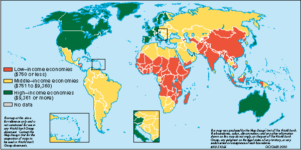
4. Using the data gathered, establish categories for each of the regions according to levels of development. Use the four categories defined by the World Bank: 1) High, 2) Upper-middle, 3) Lower-middle, and 4) Low. Determine what values you will use for each of the key indicators to classify where a country will fall within one of those four categories (you will likely need to come up with these values on your own). Note: It is best NOT to make all categories evenly distributed.
5. Once you have classified the levels of development, assign each of them a color (e.g., High = dark blue, Upper-middle = light blue, etc…). Fill in the selected color for each country on your table sheet. Pay attention to some of the cartographic principles involved in making a chloropleth map.
6. Create your map using the gathered information. Fill in the region (not just the two countries per region) with the color you chose. The map should display most of the TODALSIG elements (Title, Orientation, Date, Author, Legend, Scale, Index (not applicable) Grid (not necessary)). If two countries within one region have different colors on your data sheet, select which one would best fit the region as a whole (dark blue for high, light blue for upper-middle,...). Note: Some countries may be outliers for their respective region and should be identified as such (e.g., Australia and New Zealand are generally significantly more developed than the other island nations in Oceania).
7. Once the maps are completed, notice the implications of the pattern. Draw a line (should not be straight) separating developed and developing countries using the data to guide you. Note the general location of this line as drawn on your map. This North-South Line typically occurs at approximately 30 N latitude (with the obvious exception of Australia and New Zealand) and is commonly called the "Brandt Line" (named after Willy Brandt, former chancellor of West Germany, who first devised this line).
VI. Assessment
Data sheets and core-periphery chloropleth maps will be turned in and graded for completeness, accuracy and aesthetics. In addition, the following questions are to be answered separately:
1. Explain your rationale in choosing the four key indicators you selected, as well as the categories you established for each indicator.
2. Discuss the geographic implications of the north/south split revealed by this map.
3. Explain why the pattern on this map could be a geographic critique of Rostow's model of development. (Hint: Consider if development levels might be different if developed and less developed countries were more geographically intertwined)
4. Discuss what problems of development this geographic pattern may imply, and describe ONE aspect validiting the underlying principles of the core-periphery model.
5. What limitations might the core-periphery model have as a geographic critique of economic models of development?
All rights reserved.
Revised: April 11, 2016